Locals refer to downtown Chicago as "The Loop" because of a rectangle of elevated (or "El") train tracks that create a loop through the area first built in the 1890s. As empty nesters we moved back into Chicago in the "South Loop" and I find myself riding those rails often and thinking about how these trains traverse the circle.
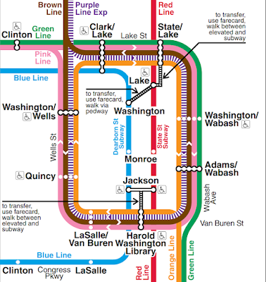
There are three ways to enter and escape the loop, South through the southeast corner, North through the northwest corner and West through the northwest corner. There are five train lines that run through the loop.
- Orange: Enters from the south, circle clockwise and out back south. Goes to Midway Airport.
- Pink: Enters from the west, circles clockwise and out back west.
- Purple: Enters from the north, circles clockwise and out back north. Goes to Evanston near Northwestern.
- Brown: Enters from the north, circles counterclockwise and out back north.
- Green: The only one that goes out a different way than in. It goes both directions from the west to/from the south.
Two more lines run underground through the loop.
- Blue: You can transfer to Blue by taking escalators down from Clark/Lake station. Goes to O'Hare.
- Red: You can't get to a loop station from Red without some walking outside. The Red line does connect with the orange, green, brown and purple lines at various stations outside the loop. The Red hits both Chicago major league baseball stadiums.
A few observations:
- No train takes the Northwest corner counterclockwise. If you want to get from Clark/Lake to Washington/Wells you need to take the whole loop in the other direction. On the other hand it is just a couple of blocks walk.
- If it wasn't for the Green Line you could get away with one track around the loop, though it might get backed up in rush hour.
- The whole idea of the loop was for a time when people would all work in downtown, the trains would come in drop people off at several stops and then head back out with no downtown terminus. Where people work has changed but the loop remains.
 |
| An elevated train traveling on the west side of the loop. |
It's funny to imagine how this would read as a Bill post.
ReplyDeleteI think you mean it is the Northwest corner where no train turns counterclockwise.
ReplyDeleteI don't understand the remark about getting away with just one track. You'd still need two tracks after taking out the green line, as the trains on the brown line runs in the other direction as the trains of the other lines. Unless you allow just one train at a time in the loop, but with that restriction, you can keep the green line.
Fixed the typo. If there were no green line, all trains could run counterclockwise on a single track.
DeleteHa! That's different. From Tokyo, anyway. Here, the loop line (Yamanote line) is a 30-station bidirectional dedicated loop connecting distinct business areas and neighborhoods, with commuter and subway lines intersecting it at various places. There are other lines that run parallel to the loop in places*, but they don't share track. Length is a tad different: Chicago: 2.88 km, Yamanote: 34.5 km. Passengers handled per weekday: Chicago: 32,000, Tokyo: 4 million. The nominal speed (55 mph) is the same. (A complete Yamanote line loop takes 59 to 65 minutes, so the average speed is something like 19 mph.)
ReplyDelete*: It's sort of an egg shape with the pointed end to the south, and major north-south lines run parralle to the two sides.
The pointy egg shape means that the trains make a logical 180 degree turn at Shinagawa Station, but there's no sense of turning as you ride the line. Thus I, despite a reasonably good sense of direction, get turned around and dizzied something fierce if I have to change lines or get on or off there.